Log in
All resources
Create a design
35,459 Free Images of Relief Map
pages with maps
cc-zero
architecture
bibliothèque nationale de france
mi yin temple
photographs by henk van gaal
map of paris by jouvin de rochefort (boutier 112)
postcards published by mid-west map
media with estimated locations
map of maastricht by willem and johannes blaeu (1649)
map of maastricht by willem and johannes blaeu (1649)
meuse river in maastricht
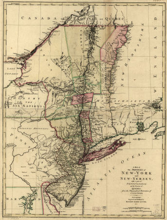
a map of the provinces of new york and new jersey, with a part of pennsylvania and the province of quebec
maps in the library of congress
1895 sanborn fire insurance map from new orleans, orleans parish, louisiana
maps in the library of congress
maps of the war of the spanish succession
apalachee
self-published work
architecture
self-published work
pages with maps
turgot map of paris, kyoto university library – derivative files
porte saint-antoine
map of paris by braun & hogenberg - derivative files
rue des archives (paris)
lawrence h. slaughter collection of english maps, charts, globes, books and atlases
nypl lionel pincus and princess firyal map division
map of paris by jouvin de rochefort (boutier 112)
pont de grammont
architecture
monument
pages with maps
cc-zero
self-published work
pages with maps
french-language maps from ios map collection
old maps of carinthia
self-published work
architecture
old submaps of paris 1er arrondissement
paris in the 18th century
a map of the british empire in america with the french and spanish settlements adjacent thereto
1730s maps of the caribbean
cartes generales de toutes les parties du monde (1658)
1650s maps of saxony
maps of paris from the david rumsey historical map collection
maps of paris by caspar merian
curt teich postcard archives, curt teich & company
postcards of cook county, illinois
postcards of madison county, illinois
curt teich postcard archives
windmills in amsterdam
singelgracht
postcards of creek county, oklahoma
curt teich postcard archives
maps from traité de la police, bibliothèque nationale de france
sixth map of paris from traité de la police
self-published work
pages with maps
self-published work
architecture
self-published work
pages with maps
turgot map of paris, kyoto university library – derivative files
plans of the palais des tuileries
backs of postcards in curt teich postcard archives
postcards of miami, oklahoma
map of maastricht by willem and johannes blaeu (1649)
grote gracht (maastricht)
map of maastricht by willem and johannes blaeu (1649)
kleine gracht (maastricht)
backs of postcards in curt teich postcard archives
postcards of clinton, oklahoma
atlas géographique des quatre parties du monde (delisle)
map of europe by guillaume delisle (1700)
beschreibung der städt der welt - braun & hogenberg - btv1b52512111k
hierosolyma clarissima totius map by braun & hogenberg
beschreibung der städt der welt - braun & hogenberg - btv1b52512111k
hierosolyma urbs sancta map by braun & hogenberg
atlas géographique des quatre parties du monde (delisle)
map of italy by guillaume delisle (1700)
self-published work
pages with maps
lawrence h. slaughter collection of english maps, charts, globes, books and atlases
nypl lionel pincus and princess firyal map division
self-published work
pages with maps
self-published work
metal
self-published work
architecture
self-published work
architecture
claes jansz. visscher (i)
joannes van doetecum (i)
voyage en perse
pasargadae
postcards of navajo county, arizona
curt teich postcard archives
john rocque's 1746 map of london
details of old maps of london
old submaps of paris 5e arrondissement
porte saint-victor (paris)
self-published work
facade
juliana of the netherlands in 1969
burgerzaal
self-published work
pages with maps
1794 maps of the holy roman empire
english-language maps of europe
german-language maps from ios map collection
18th-century maps of the black sea
bern city map of 1638 by matthäus merian
baroque
map of paris by jouvin de rochefort (boutier 112)
historical images of hôtel de ville de paris
cartography
maps
lawrence h. slaughter collection of english maps, charts, globes, books and atlases
nypl lionel pincus and princess firyal map division
united states sanitary commission
1889 books
british library - off the map alice collection - gardens
collections of the british library
british library - off the map alice collection - gardens
collections of the british library
british library - off the map alice collection - gardens
collections of the british library
1730s maps of south carolina
old maps of north america
curt teich postcard archives
postcards of miami, oklahoma
map of maastricht by willem and johannes blaeu (1649)
city gates in maastricht
self-published work
pages with maps
dutch baroque architecture
mans spoor-dijkema
self-published work
pages with maps
self-published work
pages with maps
self-published work
pages with maps
bern city map of 1638 by matthäus merian
baroque
maps
city
self-published work
pages with maps
self-published work
architecture
self-published work
pages with maps
self-published work
pages with maps
self-published work
pages with maps
a new & correct map of england and wales (foster)
1750s maps of england
self-published work
pages with maps
self-published work
pages with maps
self-published work
pages with maps
self-published work
pages with maps
self-published work
pages with maps
self-published work
pages with maps
a map of the british empire in america with the french and spanish settlements adjacent thereto
1730s maps of the caribbean
self-published work
pages with maps
self-published work
pages with maps
uploaded with vicuñauploader
pages with maps
pages with maps
architecture
self-published work
pages with maps
self-published work
pages with maps
self-published work
pages with maps
self-published work
pages with maps
pages with maps
cc-zero
works after map of amsterdam, 1544
maps in the rijksmuseum amsterdam
henricus hondius ii, nova totius terrarum orbis geographica ac hydrographica tabula, 1630
eran laor cartographic collection
atlas des anciens plans de paris by imprimerie nationale, 1880 from bhvp
map of paris by jouvin de rochefort (boutier 112)
media contributed by university of illinois urbana-champaign university library
1702 maps of africa
atlas des anciens plans de paris by imprimerie nationale, 1880 from bhvp
18th-century maps of paris
atlas des anciens plans de paris by imprimerie nationale, 1880 from bhvp
map of paris by jouvin de rochefort (boutier 112)
paintings by antônio parreiras in the museu antônio parreiras
1910s paintings by antônio parreiras
old submaps of paris 5e arrondissement
turgot map of paris – derivative files
3601 - 3700 of 35,459
Next page
/ 355